
Finding DeWitt Homes by Street
An address-led search has to separate title, parcel, and household evidence. Start with the exact physical location in the county property tools, capture the tax-map parcel and property class, and retain the assessment owner as an assessment label. Then use the parcel in the county GIS viewer for map context, follow recorded transfer parties through the land-record index, and use dated directories only for a historical address snapshot. The order matters because the same street can appear with different postal labels, and an owner’s correspondence address can be somewhere else.
- Search the physical property address through Onondaga RPTS or the 2025 final roll, then record the tax-map parcel, property location, and owner fields separately.
- Open the parcel in the county GIS viewer, note its map date and nearby parcel identifiers, and treat the display as planning information rather than a boundary survey.
- Ask the DeWitt Assessor about the parcel’s inventory, field-book, deed-transfer, and permit-copy trail when a past record is needed.
- Use the Cott index for the present owner and earlier transfer parties, preserving dates, document references, and the legal description at each link.
- For a past household, test the relevant DeWitt fiche year at OCPL and pair a directory find with census, obituary, cemetery, or newspaper evidence.
New York’s voter lookup is not a street-browsing tool. It is a self-lookup that requires the registered voter’s own name, birth date, county, address information, and ZIP code. Do not turn a property or voter record into a claim about a current household.
DeWitt Address Record Coverage
These records are keyed to an address or parcel in different ways. The street directory trail is strongest when every result keeps its own source label. A deed proves transfer parties and a date. A tax record carries an administrative owner field. A directory or telephone listing can place a named household or subscriber at an address for its published year, not for every year before or after it.
| Address record | Custodian | Historical use | Access route |
|---|---|---|---|
| Town Assessor inventory and field books | DeWitt Assessor | Parcel history from the early 1960s to today, plus inventory and permit-copy leads | Office, phone, email, or a focused records request; no public search form was located |
| RPTS assessment and tax-map record | Onondaga County RPTS | Current or final-roll parcel, property location, owner fields, and tax-map bridge | RPTS property-tax information, Image Mate public access, or official roll and tax maps |
| GIS parcel display | Onondaga County Planning | Parcel geography and map context | County GIS viewer; live field and layer labels were not captured |
| Recorded deeds and related instruments | Onondaga County Clerk | Transfer parties, dates, document references, and legal-description trail | Guest index, paid image route, Clerk counter, or Archives |
| Planning and Code records | Town of DeWitt | Permit, certificate, inspection, complaint, and fee record trail | Office or FOIL request by address and tax-map parcel; no searchable portal was located |
| DeWitt directory fiche | OCPL Local History/Genealogy | Dated name-and-address snapshot when the source includes the address | Staff-assisted fiche at call number LN48 D517 D |
County archives are the fallback when a needed instrument is not visible online. The County Clerk says its archival holdings run from 1794 to the present and include maps, while the exact online Cott start and cutoff were not located in official sources.
DeWitt Search Modes by Address
Onondaga’s legacy tax-search route gives four official ways to approach a parcel. Use one mode first, then add detail only if the result set is too broad. The recorded mode names matter because a property location and an owner mailing address are intentionally different search paths. The legacy interface did not expose a ZIP filter during inspection, and the current Beacon form could not be inspected, so neither should be described as a confirmed ZIP search.
| Official RPTS search mode | What to enter | Use on a street search |
|---|---|---|
| Tax Map Number | Exact tax-map parcel string | Best after an address search identifies the parcel |
| Owner Name | Owner name as deed | Use to connect the assessment entry with a recorded transfer party |
| Property Address | Physical location, street number, and street name | Use for the parcel on the named DeWitt street |
| Mailing Address | Owner’s mailing address | Use only when researching the tax-bill destination, not as a substitute for situs |
- Parcel
- A unit of land recorded in the assessment and tax-map system. In Onondaga materials, retain the parcel string as shown rather than rewriting it.
- Situs address
- The physical property location. It can differ from the owner’s mailing address in the roll.
- Plat
- A recorded map that lays out lots or a subdivision. It can help connect an older lot description to a present parcel.
- Criss-cross directory
- An address-arranged directory used to look for a dated household or subscriber entry at a particular location.
Note: The county warns that assessment data can change through the final roll, so confirm a current ownership question with the town assessor and Clerk record.
Map a DeWitt Street Parcel
The county Planning GIS viewer can add spatial context to a street directory search. Locate the parcel by address or parcel if the live viewer permits it, identify the parcel, record its identifier, and compare the map’s date with the property record. The county’s metadata describes 2025 parcel boundaries, with property information dated March 2025 for Syracuse and November 2025 elsewhere in the county. It also says the display is for planning and general analysis, not survey or legal-boundary work.
The Onondaga County GIS viewer is the official source for parcel geography. A parcel line can identify map adjacency, but it does not prove a shared boundary, household, ownership relationship, or current resident.
DeWitt Street Directory Deed Trail
For a recorded ownership trail, begin with the parcel and legal description from the assessment record. Search the current owner in the Cott land-record index, find the instrument that carried title to that party, and then search the seller’s earlier acquisition as a grantee. Record the transfer date, reference, and legal description with each step. The legal description is especially useful when an old deed lacks a modern street number or an address spelling changes.
The Onondaga Land Records guest route provides a free index, while images require an account or subscription. Not every index entry has an image. If a paid image is not needed, preserve the index citation; for a missing or older record, ask the Clerk or Archives for the available paper, microfilm, map, or image format.
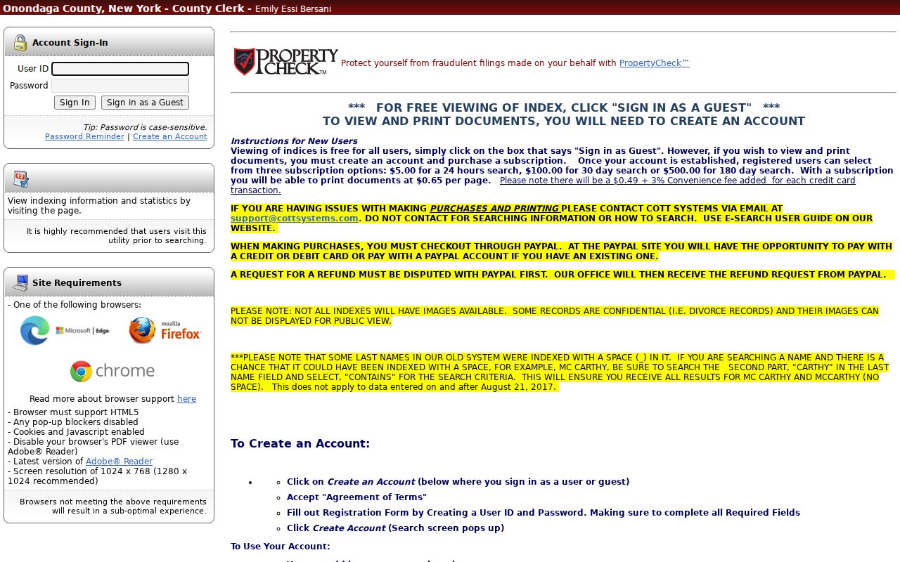
The guest-index screen is a route into transfer research, not an address directory of residents. For records before August 21, 2017, try an MC surname with a space, such as MC CARTHY, and use Last Name Contains on the second portion.
DeWitt Parcel Field Books
DeWitt’s Assessor supplies a local bridge that the online tools do not replace. The office reports ownership and inventory information for more than 11,000 parcels and field books that cover each parcel from the early 1960s to today. It also receives permit copies from Planning and Zoning and maintains computer and field-book entries, appraisal photographs, and inventory cards for assessment work. Those holdings can be useful when a transfer or change is not visible in a public interface.
Field books are not described as an online or open-copy collection in the research. Ask the DeWitt Assessor whether a particular parcel has a record available for inspection, what years it covers, and how the office wants an address and parcel identified. Keep a field-book reference distinct from a deed or directory entry.
Note: The 11,000-plus figure counts parcels, not people, and should never be turned into a count of DeWitt residents.
DeWitt Address Permit Records
For work or code activity tied to an address, the fallback is an office or records request rather than an invented online portal. Town Code §94-13 requires the code-enforcement official to maintain permanent official records of applications, plans, permits, certificates of occupancy, stop-work orders, operating permits, inspections and tests, statements and reports, complaints and investigations, and fees. This can help document an alteration or municipal action at a parcel. It does not identify who occupies the property.
The DeWitt Town Clerk is the Town records custodian and FOIL Officer. A focused request should identify the physical address, tax-map parcel, approximate period, and the named record category. New York FOIL gives access to existing records; it does not require an agency to create a new address history or reach a conclusion from its files.
Use the Clerk route where permanent records are not searchable by address online. Send the request to the office that maintains the record, not a general county desk.
DeWitt Street Directory Fiche
OCPL’s Local History/Genealogy collection holds a specific DeWitt fiche run for 1953, 1955, 1957, 1959, 1961, 1963, 1967, 1969, 1972, 1974, and 1985 under call number LN48 D517 D. The gaps in that holdings row do not prove a directory was never issued. They show only that those omitted years are not listed in the identified DeWitt fiche row. A Syracuse or suburban directory is a different collection and needs a geographic check before an address is treated as a DeWitt entry.
Request a bounded surname, address, and year from OCPL staff, including spelling variants. A dated directory line can support a historical household snapshot if the source actually carries that address. The broader shelf, access path, and collection limits are described on the DeWitt city directory page.
DeWitt Street Postal Labels
DeWitt is a town, while mail can use several delivery labels. The working research list identifies 13057, 13066, 13078, 13206, 13211, 13212, 13214, and 13224 as labels touching the DeWitt research area. The county generalized ZIP map warns that its boundaries are approximate and may extend outside the county. It should not be used to decide jurisdiction for a particular house.
Use the USPS ZIP Lookup to standardize one delivery address. USPS is authoritative for that formatting and city line, but it says its result does not confirm a person or organization at an address. Where a mailing line, postal city, and property location disagree, retain the source labels and verify the parcel through RPTS, GIS, or the tax map.
DeWitt Address Archive Context
Older street research often needs an offline step. The Onondaga County Clerk Archives reports records from 1794 to the present, more than 47,320 cubic feet of files, and 1938 aerial maps. Ask by municipality, former owner, parcel, subdivision, street, and approximate date. An aerial image can place an older road or landscape in context, but it is not a survey and it does not name a household.
No official DeWitt street-renumbering or historical road-name register was located. When a number or street form does not match a deed, keep the parcel/SBL and legal description as the stable trail, then test old and new address forms in directories and records. Report an unresolved number change as a gap, rather than guessing at a match.
Note: The County Clerk Archives holds countywide material, so an archive search may have a DeWitt lead without offering a DeWitt-specific online index.
DeWitt Street Directory Limits
A street directory search can establish parcel geography, an assessment-owner field, a recorded transfer, or a historical source entry. None of those labels establishes that a named person currently lives at the address. The state voter self-lookup is restricted to the voter’s own match, and confidential voter registrations are maintained separately. Keep current-owner, mailing-address, grantor, grantee, and historical directory labels separate throughout the research trail.
Lawful use. DeWitt address records can support house history, family research, civic questions, and personal record checking. Do not use them to stalk, harass, intimidate, or harm anyone.